Everest Trek: Plans and Preparations
We had arranged a 20-day trek in the Everest Region of eastern Nepal. We would fly from Kathmandu to Lukla to avoid the long approach walk into the mountains from Jiri (which would add a few more weeks to the trek – it’s meant to be a beautiful walk but we just didn’t have the time).
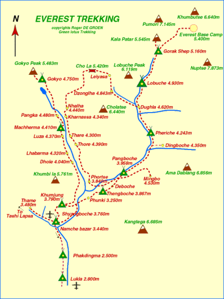
Our plan was to follow the following classic Everest route shown in the map below (but traveling the reverse direction around the "loop"):
This map gives you some idea of the elevations that we were trekking at, and the height of some of the mountains in the region:
From Lukla we planned to walk a couple of days to the central town of the region, Namche Bazaar where we would spend a day acclimatizing. We would then walk further north and take the eastern branch of the valley which would lead us up towards Gokyo. There, we would spend a few days to climb Gokyo Ri and explore the valley further. To cross back over into the western valley we would ascend over the high Cho La pass to Dzongla and then walk further north as far as Everest Base Camp and Kala Pattar, which we would explore from Gorak Shep.
Eco Trek, our trekking company, arranged two experienced staff to accompany us for the duration of the trek: Shiva (guide) and Kumar (porter). They weren’t sherpas native to the Everest region, but came from a different mountain region north of Kathmandu. These wonderful people leave behind their families and their farms to work for about 10 months of the year as guides/porters because the money is so good – we were sure to go with a trekking company that paid and treated its staff well.


